History of the Ginninderry project
|
c21,000BP |
Indigenous occupation
Evidence has been found of Aboriginal habitation along the Murrumbidgee River some 21,000 years ago. Artefacts discovered on the Ginninderry site suggest that the area along the Murrumbidgee River and lower Molonglo River was used as a focus for hunter-gather economic resource exploitation up to the time of white settlement. |
| Early 1820s | First Europeans |
| European explorers reach the Murrumbidgee and Molonglo Rivers and occupation of grazing lands begins. A number of land grants made to absentee owners. | |
| 1826 | George Palmer takes up land in the Ginninderra Creek area. He formally requested permission to purchase the land in 1829, which was granted by the colony of New South Wales in 1831. Robert Hoddle then surveyed the land in 1832, followed by James Larmer in1836. |
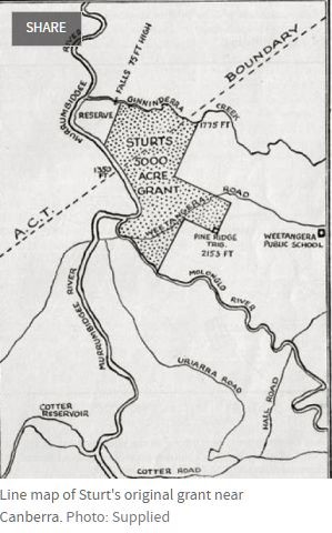
| 1835 | Charles Sturt’s selection |
| Sturt initially selected the land in 1835 and was surveyed by NSW’s Deputy Surveyor General, Robert Hoddle. It was then gazetted in 1836. | |
| 1837 | New South Wales Government granted 5000 acres (2000 hectares) of land to explorer Charles Sturt in recompense for his expeditions. It was bounded by waterways on two sides and crossed what is now the ACT border. Sturt called the property the ‘Grange’. |
 |
|
| 1838 | Sturt’s land sold to Campbell family
Sturt sold his holding to the Campbell family of Duntroon who named it Belconnen, variously spelled as Belconnel, Belconon and Belcomon. The farm was developed by Charles Campbell as a sheep property and in 1850 he had a stone house built on it, now known as “Belconnen Farm”. |
| 1854 | Ginninderra Creek, Parkwood and The Falls |
| Thomas Southwell arrived in the Ginninderra district in 1840 and worked as a farmer and carrier. In 1854, he bought land at the junction of Ginninderra Creek and Murrumbidgee from absentee owner Alick Osborne and named it Parkwood. | |
| 1861 | After the passage of The Free Selection Act of 1861, Robert Kilby and his father William, who came to NSW in 1856, established a 16ha freehold farm, ‘Land’s End’ in the parish of Weetangera. |
| 1877 | Charles Campbell’s son Frederick took over the management of Belconnen in 1877 and employed overseers and staff for his holdings and those who managed Belconnen included Richard Vest, D Macdonald and Duncan McInnes. |
| 1895 | James Kilby, son of Robert, acquired crown land overlooking the junction of Ginninderra Creek and the Murrumbidgee next to Thomas Southwell’s Parkwood. The land included Ginninderra Falls and he named his property ‘The Falls’. In 1897, he married Thomas Southwell’s daughter Beatrice. In 1910 James bought Parkwood and the two properties became one. |
| 1910 | ACT borders surveyed |
| After Federation, land was granted by New South Wales for the new capital. Surveying of the borders commenced in 1910 and the “straight bit” between existing trig points at Mt Coree and One Tree Hill was determined first as a matter of convenience. The other borders were determined by water catchments. The straight line between the trig points cut through the natural peninsular of land bordered by the Murrumbidgee River and Ginninderra Creek. Natural boundaries mean the only practical access to this land is via the ACT. | |
| 1910 | ACT leases created |
| The passage of the Seat of Government (Administration) Act 1910 meant all property within the ACT was resumed by the Crown and became leasehold rather than freehold. The section of land in NSW north of the border (now known as Parkwood) remained freehold. | |
| 1913 | Belconnen Farm leasehold |
| The leasehold of the Belconnen Farm area in the new Federal Capital Territory was acquired by the Miller family. With the introduction of the Soldier Settlement Scheme following World War I the Belconnen Farm lease passed to Austin Shepherd. The lease was extended several times and the Shepherd family continued to operate the sheep property until 2004. | |
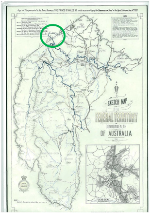
| 1922 | Prince of Wales plan |
| When the Prince of Wales visited Australia in 1920; he was presented with a plan of the Territory, which included the section of NSW land bordered by the Murrumbidgee and Ginninderra Creek. The logic of the cross-border geography was already being recognised. | |
 |
|
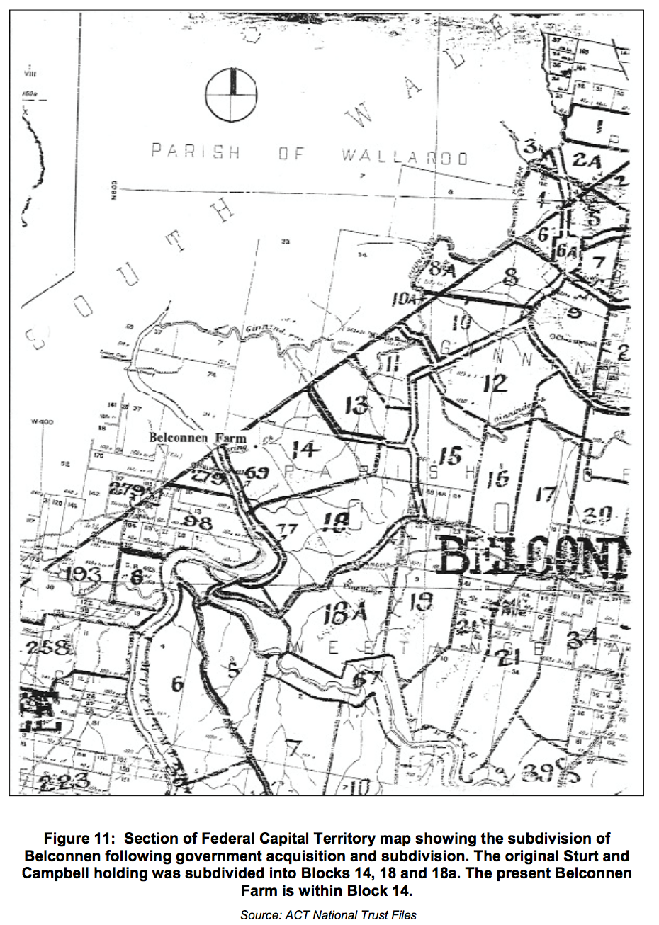
| In 1922 the former Sturt land grant and Campbell holding was subdivided into Blocks 14, 18, and 18a. The present Belconnen Farm heritage area was within Block 14. | |
 |
|
| 1970 | Parkwood, with the exception of 25 acres, which remained in Kilby family, was sold to consortium interested in development |
| 1979 | Ginninderra Falls Park opened to the public with trails developed by lessees of the consortium, Robert and Elizabeth Caldwell. |
| 1984 | Corkhill farming property |
| As a result of the failure of the consortium’s plans, Parkwood was split up and sold or leased to a number of buyers. Parkwood land in NSW was bought by the Corkhill family as a farming property. | |
| 2002 | Family farm extended |
| The family sought to extend their farm and increase its viability by entering into a contract to acquire a new 99-year rural lease in the ACT. The lease was approved in 2004 and the purpose clause limited the use to ‘agriculture’. | |
| 2004 | Spatial plan |
| The ACT Government’s Spatial Plan identified a portion of the land as having potential for residential use. | |
| 2006 | Cross-border concept first raised |
| The concept of a cross-border residential community was first raised with the ACT Government, the Yass Valley Council and the National Capital Authority. This initiated a series of meetings with the ACT Government and baseline studies taking place through to 2009, as the idea was explored and a plan developed. | |
| 2007 | Community consultation begins |
| Consultation covered a wide range of topics including conservation, community services, recreation, transport, municipal services, environmental management, renewable energy and housing affordability. The outcomes of the early consultation were fed into the design of the engagement processes for the master planning phases of the project. | |
| 2010 | Inter-departmental committee set up |
| The plan was referred by the ACT Chief Minister to an inter-departmental committee (IDC) for further investigation of the proposal for a joint venture. After consultations with a range of government entities, the IDC proposed a structure for a 50/50 Joint Venture Board between Riverview and the then ACT Land Development Agency, with an independent Chair. | |
| 2012 | ACT Planning Strategy |
| In 2012, the ACT Planning Strategy identified the ACT portion of the land as ‘future urban investigation area’. | |
| 2013 | Heads of agreement |
| In May 2013, the ACT Government announced an agreement with Riverview Developments, to facilitate the planning and development of new suburbs adjacent to the existing suburb of Holt in the ACT over the next 30 years. This was a significant milestone in the engagement process related to the proposed development of Ginninderry. | |
| 2013 | ACT Land Development Agency (LDA) involved |
| In June 2013 the ACT Government identified the then LDA as the ACT’s representative in the proposed Joint Venture, tasked with obtaining value for the Territory from the development project. | |
| 2014 | Re-zoning applications lodged |
| Re-zoning applications were lodged with for ACT Government/National Capital Authority approval and with Yass Valley Council on 30 June 2014. | |
| 2015 | NSW Planning Proposal |
| The NSW Planning Proposal was considered by Yass Valley Council and the NSW State Government and determined to be compatible with the proposed Yass Valley Settlement Strategy (Yass Valley Shire Council) and the Sydney-Canberra Corridor Strategy (NSW Department of Planning). | |
| 2016 | Rezoning |
| The ACT land was re-zoned and the lease surrendered by the Corkhill family at an amount calculated by independent valuation to equal the value of the property under the current terms of the rural lease. The plan for a cross-border community allowed zoning to the border. | |
| 2016 | Joint Venture commenced |
| The Joint Venture (JV) commenced in May 2016. The split of benefits between the JV partners was based on a residual land valuation approach and took into account each party’s contribution and costs. It considered the net developable area (the land, minus the conservation corridor and landfill site) and the combined benefits that accrue to both parties. | |
| Net developable area: | |
| ACT 63% Riverview 37% | |
| Development benefits | |
| ACT 56% Riverview 44% | |
| Agreed JV position | |
| ACT 60% Riverview 40% | |
| The agreed JV position is the negotiated equity split after taking account of the above analysis and benefits of planning and delivery for both parties. | |
| 2016 | Development approvals |
| ACT Planning Authority approved the ACT portion of the project and the National Capital Plan Amendment was approved, allowing development in the ACT up to the border. | |
| 2017 | Sales commenced in the ACT |
| The first sales at Ginninderry took place in April 2017 with more than 1300 individuals registering for blocks of land and the affordable flexi-living series in the first suburb of Strathnairn. | |
| 2017 | EPBC approval |
| On 1 September 2017, the West Belconnen Strategic Assessment (SA 024) for the Ginninderry Joint Venture (JV) project was approved by Minister Frydenberg, Commonwealth Minister for the Environment and Energy, an important environmental milestone which, together with the necessary planning approach, will allow urban development to proceed. | |
| 2018 | NSW approval expected |
| The NSW Planning Proposal is expected to be publicly exhibited in early 2018, then re-considered by Council and referred to State Government for review, with a decision from the NSW Planning Minister on rezoning expected in late 2018. |